The sunchart is one of the basic solar energy design tools. With proper knowledge, both professional and amateur solar designers can use the sunchart to efficiently and easily design and positionally optimize solar collectors, solar electrical panels, passive solar homes, greenhouses, and other solar devices. SolarPhotons provides this homepage to disseminate basic information on using suncharts as tools for designing and optimizing your solar energy projects.
INTRODUCTION
TABLE OF CONTENTS
|
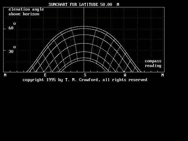
| Figure 1 shows a typical cylindrical sunchart for 50 degrees north latitude. |
|
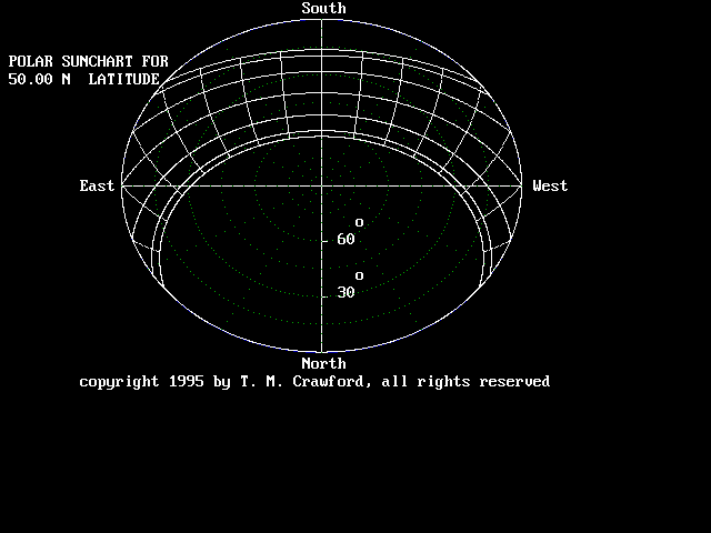
Figure 2 shows a typical polar sunchart for 50 degrees north latitude. |
Figures 1 and 2 show two typical suncharts for 50 degrees north latitude. These suncharts map out the path that the sun takes on approximately the 21st day of each month. The lowest or shortest path represents the first day of winter (approximately December 21), while the highest or longest path represents the first day of summer, (approximately June 21). The other paths each represent two months during the year, and are drawn at monthly (30 to 31 day) intervals. This is explained more in a following section of this paper.
Also on these suncharts, iso-time curves connect the solar path curves to provide time-of-day information. These curves are drawn an hour apart, with solar noon being along the y-axis of the sunchart. Using this information, it is easy to determine where the sun is at any time of the day. Note that this information is in sun time instead of real time. Solar noon is defined as the time when the sun reaches its highest point in the sky. Conversions between sun time and real time can be done using mathematical functions of latitude, longitude, and time of year. This will again be discussed in a following section of this paper.
Several simple but important observations can be made directly from these two suncharts:
Two types of suncharts, shown above, are useful for performing solar energy calculations. Though not true physically, we can envision the sky to be the inside surface of a hemisphere or dome on which the sun, moon, stars, and planets are constrained to move. This hemisphere or dome is called the skydome. In order to locate the sun's position on the surface of the skydome at any time, we need two coordinates, the altitude angle and the azimuth angle. The altitude angle measures the sun's location above the horizon, with 0 degrees being on the horizon and 90 degrees being straight overhead. The azimuth angle measures the sun's location in degrees east or west of due south (northern hemisphere assumed). Eastern angles are defined as negative with due east located at -90 degrees; western angles are defined positive with due west located at +90 degrees.
We can map the altitude and azimuth solar coordinates in several different ways. Two of the most useful solar maps or suncharts are the cylindrical sunchart and the polar sunchart. Both types of suncharts provide exactly the same information, but they each provide a different way to visualize the data. Your preference will depend on your application.
A cylindrical sunchart is a cylindrical projection of the skydome. This is the type of sunchart shown in figure 1. It is plotted in Cartesian coordinates. The cylindrical sunchart shows the path which the sun will appear to take to an observer looking due south (in northern latitudes). This appears to be the preferred form of sunchart, and various interpretive tools have been developed for use with this type of sunchart. The cylindrical sunchart is useful for conducting shading calculations. It is also useful for visualizing the sun's path at high latitudes, especially for the winter months when solar energy is more important. Its major disadvantages occur when the sun is high in the sky (summer months & lower latitudes). This type of sunchart is very confusing in tropical situations.
The polar sunchart on the other hand uses polar coordinates to map out the sun's path. It projects the sun's path looking down onto a flat plane, with the observer being directly in the center of the plane. This is the type of sunchart shown in figure 2. It provides exactly the same information as the cylindrical sunchart, but in a different format for visualization purposes. The polar sunchart makes it much easier to visualize the compass direction of the sun at any point in time. It is easier to use at tropical latitudes and during the summer months. For some reason, this type of sunchart does not seem as popular as the cylindrical version, but it should be just as useful, especially in certain applications. Since both types of suncharts provide the same information in different formats, personal preference and the visualization effects you want to achieve should govern your choice of sunchart.
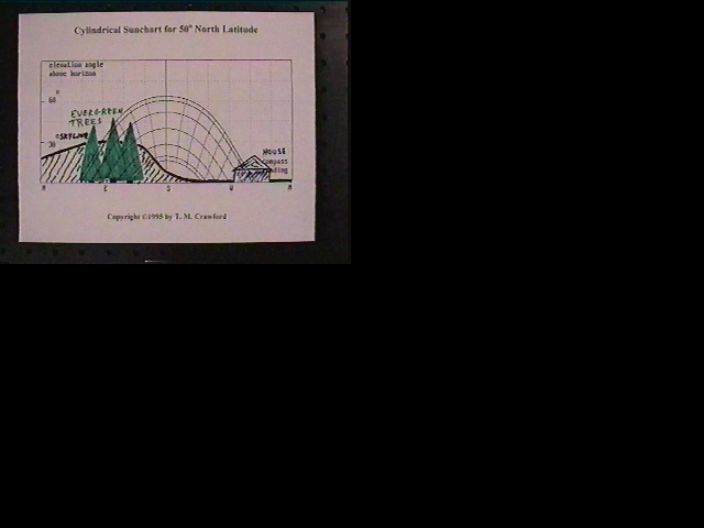
| Figure 3 illustrates how sketching a skyline and other objects onto a sunchart make it a useful tool in predicting how the objects will block the sun during the year. |
Directions for plotting a skyline onto a sunchart:
Geographical obstacles are sometimes unavoidable. Many times, a portion of the sunchart may be blocked by a large object which cannot be removed or compensated for by changing locations. An example of this may be a large hill, mountain, building, or stand of trees. As mentioned above, figure 3 shows examples of these situations. If this occurs and no better building site is available, then the sunchart can be used to help orientate a building or solar collector to optimize the sun's energy that the collector receives. Using the sunchart with the appropriate skyline plotted onto it, approximate with your eye the azimuth angle at which the most direct light falls onto your window or collector. Orientate your building or solar collector accordingly. In the example shown in figure 3, a hill and some trees block the morning sun in the winter until about 11:00 AM solar time. A solar collector would need to be turned about 15 degrees west of south to make the best use of the sun's rays.
Constantly recurring meteorological conditions can also limit the amount of solar energy a site receives. In many locations, morning fog, marine layers, and similar meteorological conditions can block the sun until the later morning hours when the sun "burns" it off. If situations like this occur in your area, shade off the portion of your sunchart up to the approximate solar time when this condition usually disappears. Treat this shaded portion just as if it were part of the skyline, and use the above technique to again estimate the new azimuthal angles at which buildings or solar collectors should be oriented to compensate for these conditions and thereby optimize the collected solar energy.
Optimum solar collector elevation angles can also be approximated using the sunchart. Many solar engineering books provide rules of thumb for setting solar collector elevation angles. Unfortunately these rules of thumb apply only to very specific situations, and they do not account for the special situations that need to be taken into account. The sunchart will allow you to visually approximate the optimum solar collector elevation angle. Suppose we use the above sunchart (figure 3) as an example, and we would like to position a solar collector to gather energy during the winter months for heating purposes. We have already determined that a solar collector should be oriented about 15 degrees west of south. We now need to determine the elevation angle at which to point the solar collector to obtain maximum use of the sun's rays. If we use just the lower three curves (ie - the fall & winter curves), and then estimate an imaginary elevation line where the available sun falls equally above and below that line, then we can approximate the optimum solar collector elevation angle which we should use for collecting solar heat. In this case, the solar collector should be pointed approximately 10 to 15 degrees above the horizon to make the best use of the winter sun. If needed, a better calculation could be performed using SolarPhotons' SUN_OPT software.
The sunchart can also be used to perform shading design calculations. In many cases, passively solar heated buildings can be designed to collect solar energy during the cold fall and winter months, and yet, through the use of shading devices, reject the sun's energy during the hotter spring and summer months. The sunchart is a useful design tool for these applications. Two basic types of shading devices are used for this purpose. Horizontal overhangs, if properly designed, shade much of the window during the summer months when the sun is high in the sky, while letting in most or all of the sunlight during the winter months when it is a useful heat source. Vertical columns along side a window can also be used to shade the window during the summer months while letting sunlight through during the winter months. Plants properly located can also be useful to block summer sun while allowing winter sun through. With some geometrical knowledge, and a little patience, one can plot out the effects of these and similar shading devices on the sunchart. Computer software can also perform these shading calculations and plot them directly onto the sunchart.
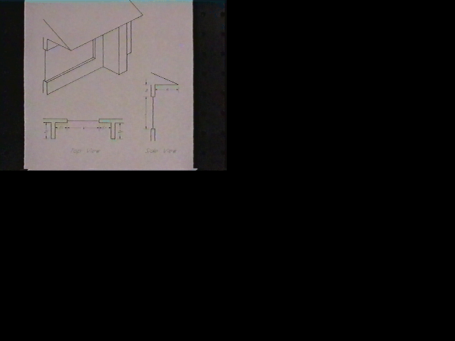
| Figure 4 shows the geometry of a window where horizontal overhangs and vertical columns are used to control the sun's rays entering it throughout the year. |
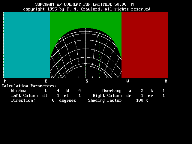
| Figure 5 - South facing shading diagram with a 100% shading factor. |
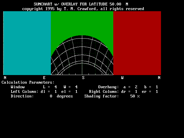
| Figure 6 - South facing shading diagram with a 50% shading factor. |
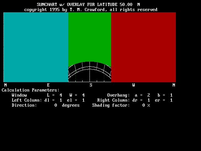
| Figure 7 - South facing shading diagram with a 0% shading factor. |
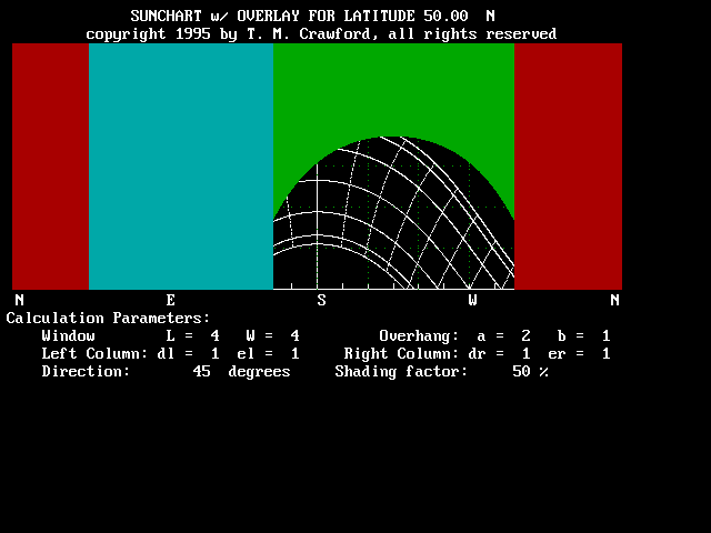
| Figure 8 - Southwest facing shading diagram with a 50% shading factor. |